FS2020: Northwestern Kimberly Coast
Jump to navigation
Jump to search
Northwestern Kimberly Coast, also referred to as Derby to Kununurra, is a Bush Trip in Microsoft Flight Simulator (2020). This bush trip is flown in the JMB VL-3 and consists of 3 legs over a distance of 222 nm with an estimated cruise time of 2 hours and 22 minutes.
| “ | Northwestern Australia's Kimberley Coast is a realm of incredible pristine beauty seen by few. Here ,the harsh desert meets the waters of the Indian Ocean along a shoreline of cliffs, vast numbers of islands, and beaches that disappear into the distance. In this bush trip, you'll be treated to aerial views of the very best of this region. Beginning at Beagle Bay Airport, the journey winds along landscapes and seascapes of the coast, allowing intimate views of natural detail as well as broad, grand vistas of sea, land, and sky. The flight ends on the Mitchell Plateau, a feature surrounded by low mountains and hills that is one of the least populated areas not just in Australia, but on the planet. Assistance on the trip will be available in the form of a 'Back of Track' button — however, be advised that using this will disable achievements tied to the activity. |
” |
Route
| Leg | Next Landing/ City |
Location ID | Distance (NM) |
Flight Time (hh:mm) |
Use Type | Fuel (100LL) |
|---|---|---|---|---|---|---|
| 0 | Beagle Bay Airport Beagle Bay, Kimberley, Western Australia |
IATA: BEE ICAO: YBGB |
originating airport | ??? | ??? | |
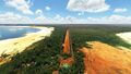
| 1 | Cape Leveque Airport Kimberly, Western Australia |
ICAO: YCLQ | 54.66 | 00:25 | public | ??? |
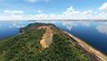
| 2 | Cockatoo Island Airport Kimberly, Western Australia |
ICAO: YCTI | 55.86 | 00:25 | private | ??? |
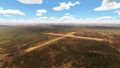
| 3 | Mitchell Plateau Airport Kimberly, Western Australia |
IATA: MIH ICAO: YMIP |
166.71 | 01:16 | ??? | yes |
History
World Update VII: Australia (WU7) (2022-01-31):
- Added Northwestern Kimberly Coast - Derby to Kununurra - JMB VL-3
External links
- Interactive route map by user Thadius856 using Google Earth (web)
Airport previews
01 - YCLQ
02 - YCTI
03 - YMIP


