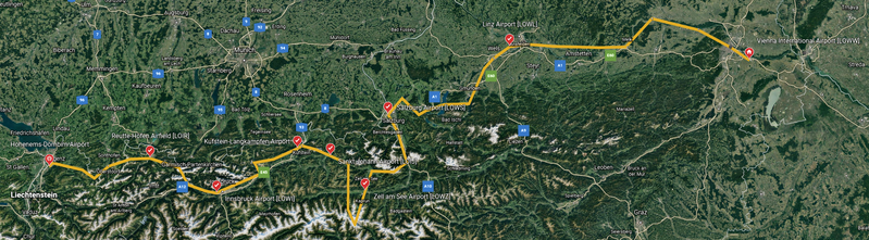
File:FS2020-Bush Trip-Map-Austria Tyrol High Mountains.png
Jump to navigation
Jump to search


Size of this preview: 799 × 221 pixels. Other resolutions: 320 × 89 pixels | 2,158 × 597 pixels.
Original file (2,158 × 597 pixels, file size: 3.66 MB, MIME type: image/png)
Summary
Created with Google Earth (web).
Interactive version publicly available at https://earth.google.com/earth/d/1v8MjqI62ZfRmbbcKZcysZh0ZBteOY9nv?usp=sharing.
File history
Click on a date/time to view the file as it appeared at that time.
| Date/Time | Thumbnail | Dimensions | User | Comment | |
|---|---|---|---|---|---|
| current | 18:47, 22 February 2023 | 2,158 × 597 (3.66 MB) | Thadius856 (talk | contribs) | == Summary == Created with Google Earth (web). Interactive version publicly available at https://earth.google.com/earth/d/1v8MjqI62ZfRmbbcKZcysZh0ZBteOY9nv?usp=sharing. |
You cannot overwrite this file.
File usage
The following 2 pages use this file: